Thursday, November 3, 2016

Babji zob, Bled's Karst Cave System


Almost the entire country of Slovenia is karstic, given that soluable limestone is a predominant feature in the region. In fact, it is the region of Kars (or Krs), meaning "stone" in Jugoslav, that "provided the name for all such phenomena in the world." [1] 

Specific to Bled are the caves under Babji zob (Hag's Tooth), a protruding rock jutting out of the Jelovica plateau, with a peak of 1,128 meters high. The karst caves under Babji zob formed from subsurface dissolution weathering, dating back to the ice age, "when the water from the Bohinj glacier invaded the inside of the Jelovica plateau." [2] 


Babji Zob in the Jelovica Plateau (Image Credit: http://www.bohinjskabela.si/en/attractions/cave-under-babji-zob)

The Suha stream runs through Bohinjska Bela in Bled, arriving at the Iglica Waterfall. At 18 meters high, Iglica falls before a vertical limestone wall, which is part of the limestone region out of which the Babji zob cave system is carved [3]. The mouth of the cave itself is 1,008 meters above the villages of Bohinjska Bela and Kupljenik set in the valley below, indicating some faulting and folding to the region, and thus a tectonic as well as karstic origin to the cave system. Certainly, the Babji zob protrusion indicates downfaulting, typical of a horst and graben formation, which, accounts for the cliffs, while traces of dolines can also be found. An Arial view of Bohinjska Bela reveals the tectonic and karstic landscape, indicative of a Polje. Notice how on the left of the picture, cliffs are clearly visible, while on the right and upper portions, more rolling hills can be seen.

Ariel view of  Bohinjska Bela (Image Credit: http://www.penzion-bevc.si/en/lokacija.php)

The interior formation of the 300 meter cave system is similar to those found in other karst regions. However, these particular caves have some rare features: although in the interior of the caves you will find the familiar speleothems such as stalactites and stalagmites, there are also rare helictites, the gravity-defying, spiral, snail-like speleothems.

Inside Babji zob Cave. (Photo Credit: http://www.bled.si/en/what-to-see/natural-sights/the-cave-under-babji-zob)


Interior Babji zob cave. Coiling Helictite can be seen on upper right corner. (Image credit: http://slideplayer.com/slide/9305498/)


[1] http://www.bled.si/en/what-to-do/highlights-of-slovenia/slovenian-karst
[2] http://www.bohinjskabela.si/en/attractions/cave-under-babji-zob
[3] http://www.bohinjskabela.si/en/attractions/the-iglica-waterfall

Saturday, September 17, 2016

Formation and Plate Tectonics of Lake Bled, Slovenia

Lake Bled features Slovenia's only naturally occurring island. Lake Bled is set within a tectonic basin, which was created around 15,000 years ago [1]. After the last ice age, the Bohinj Glacier melted and flooded the basin, forming both Lake Bled and Lake Bohinj [2]. Bled Island, set in the middle of Lake Bled, was formed through erosion and weathering.
Lake Bled
From: https://www.lonelyplanet.com/a/slovenia/lake-bled/pois/sights/490156/places/360712
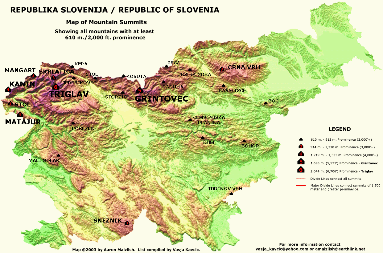
The basin was formed due to the tectonic uplifting of the Alps. The Alps mark the point of intersection between two converging tectonic plates; the African and Eurasian plates [3]. The Julian Alps are the portion of the Alps adjacent to Slovenia, acting as the country's northwestern border. Mount Triglav is the highest peak in this region of the alps, at 9,396 feet (~2864 meters).
Map of Peak Elevations
From: http://viewfinderpanoramas.org/prominence.html
Mount Triglav (Slovenia's Highest Peak)
From: http://www.traininginparadise.eu/wp-content/uploads/Mount-Triglav-the-North-wall-foto-Dan-Bri%C5%A1ki.jpg

The size of the Mount Triglav (just northwest of Lake Bled) is due to the convergence of the the African plate into the Eurasian plate, which took place 34 to 23 million years ago [4]. Although the formation of the Alps was a very ancient process as far as geological time is concerned, tectonic shifting between these two plates still affects the region today. For instance, there have been 25,000 earthquakes recorded in the last 10 years in Slovenia, and the country is considered "moderately vulnerable." Of the 25,000 recorded, about sixty have been dubbed "devastating" [5]. The map below details the different intensities of seismic activity affecting the country. Notice that blue colored area in the northeast (not the one on the border, but the one further inland) is almost directly over the Lake Bled area, making Bled very vulnerable to seismic activity. This makes a lot of sense, given that the region is set within the tectonic basin created by the convergence boundary between the African and Eurasian plates.


Wednesday, August 24, 2016

Introduction: Bled, Slovenia

Dobrodošli! Welcome to my brand new blog on the physical geography of Bled, Slovenia. My name is Anthony Ballas, I am an English and philosophy double major with a minor in religious studies at the University of Colorado at Denver. I am in my last semester at UCD, and I am set to graduate this December. In my spare time I enjoy reading, tennis, cooking, and watching movies. 

I have chosen to do my Geography 1202 project on Bled, Slovenia. Bled is a beautiful town in northwest Slovenia, about 35 miles outside of the capital city Ljubljana. Some of its major landmarks include the Vintgar Gorge, Lake Bled, and Triglav National Park.

Waterfall at Vintgar Gorge - Photo by Luke Price

I am interested in Bled for its diverse geographic features: the town is situated just south of the Karavankas mountain range which separates Slovenia and Austria, there are wetlands with lakes, rivers, and natural mineral springs, as well as heavily wooded areas and remnants of primeval forest. There is also an island right in the middle of Lake Bled, which is adorned with a 17th century church.

Soča River, Triglav National Park - Photo by Jill London
By studying Bled and its unique and diverse landforms I hope to gain an understanding of the physical features of the region, how they function, how they change, have changed, and perhaps what types of changes the region will face in the coming future. I am particularly interested to learn the ways in which human interaction and the natural environment have both carved out and shaped, and continue to shape, the Bled landscape. 

Assumption of Mary Church, Bled Island, Lake Bled - Photo by Ryan Li